
Leuchtenberg
92705 Leuchtenberg, Deutschland
Lerautal near Leuchtenberg | Hiking & Photos
The Lerautal near Leuchtenberg is not just any point on the map, but a small, landscape-dominated natural experience in the Upper Palatinate Forest. The approximately 1.5-kilometer-long section of the Lerau lies at the foot of Leuchtenberg Castle, has been under nature protection since 1938, and encompasses around 91 hectares with the adjacent forest areas. Those looking for photos, images, or hiking ideas will not find a staged attraction here, but a wild romantic combination of stream, rocks, forest, and historical backdrop. This mixture makes the area highly relevant for inquiries related to hiking, photos, images, and nature experiences. The official tourism presentation speaks of impressions from the Lerautal and simultaneously refers to further signposts and hiking opportunities within the framework of the GEOPARKS Bavaria-Bohemia. The Lerautal is freely accessible, free of charge, and thus a place that can be easily planned for a day trip, a short hike, or a combined tour with Leuchtenberg Castle. ([leuchtenberg.de](https://www.leuchtenberg.de/freizeit-tourismus/lerautal/))
Images and Impressions from the Lerautal
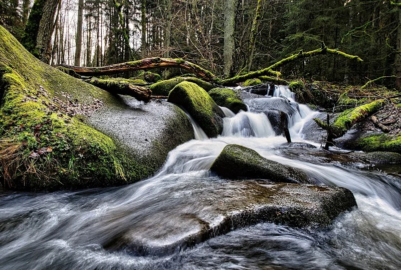
Those searching for images of the Lerautal near Leuchtenberg are actually looking for motifs that simultaneously show nature and structure. This is exactly what the official pages provide: The market portal Leuchtenberg presents several “impressions from the Lerautal,” while the tourism portal of the Upper Palatinate Forest offers additional image motifs and a visual classification of the natural space. The valley is photographically alive with contrasts. There is the calm stream of the Lerau, there are the rocks of the Wolfslohklamm, there are the granite block seas and the spheroidal weathering in the valley floor, and above lies the forest landscape, which makes the area appear differently in every season. Those who are out with a smartphone, camera, or simply with an open gaze will find motifs here that are not only suitable for classic landscape photos but also for detailed shots of rocks, forest structure, and stream. The official appearance of the place is deliberately inviting and close to nature: no artificial event backdrop, but a real protected area with strong contours. For visitors specifically searching for “lerautal near leuchtenberg photos” or “images from lerautal near leuchtenberg,” this authenticity is often the real charm. ([leuchtenberg.de](https://www.leuchtenberg.de/freizeit-tourismus/lerautal/))
The location also helps the images. The Lerautal is not isolated but is in direct proximity to Leuchtenberg Castle and in a valley area described by the tourism portal as wild romantic. This creates typical perspectives where nature and cultural landscape intertwine. Here, one does not just photograph a stream or a rock, but a landscape with history that stretches from the valley floor to the castle. This makes the Lerautal so strong for visual content: The atmosphere is calm but not empty; original but not unwelcoming; compact but rich in details. These impressions are also linguistically emphasized on the official pages when speaking of an invitation to the “beautiful nature.” So, those looking for photos or images will find less a single postcard motif than a whole series of scenes: forest path, rock, stream, castle view, geology, and seasonal changes. This is precisely how the visual language of the Lerautal emerges. It is factual, natural, and at the same time very distinctive. ([leuchtenberg.de](https://www.leuchtenberg.de/freizeit-tourismus/lerautal/))
Hiking in the Lerautal: Goldsteig, Burgenweg, and Circular Hiking Trails
The Lerautal is especially interesting for hikers, and not just because of its location. The tourism portal describes the valley section as part of a well-walkable path through which the Burgenweg runs. This Burgenweg is in turn part of the Goldsteig, one of the most famous long-distance hiking routes in the northern Upper Palatinate Forest. On the official hiking page of the market Leuchtenberg, the Burgenweg is classified as part of the Goldsteig; it states that the route connects Marktredwitz with Waldmünchen over a length of 160 kilometers. This is important for the Lerautal because it does not appear as an isolated walking area but as a section of a larger hiking network. So, those searching for “lerautal near leuchtenberg hiking” or “goldsteig lerautal” receive a clear answer here: The valley is not a minor matter but a landscape-prominent corridor within a popular long-distance hiking landscape. Particularly attractive is that the path through the valley is described as well-walkable, making it interesting not only for pure long-distance hikers but also for day visitors. ([oberpfaelzerwald.de](https://www.oberpfaelzerwald.de/lerautal))
Additionally, there is the Leuchtenberg Circular Hiking Trail, which starts in the village and leads over Steinach and Lerau towards the nature reserve. The route description mentions the forest of “Elm,” the distinctive nature reserve Lerautal, the rock formation Wolfslohklamm, and a detour to the granite rock “Teufels Butterfaß.” This sequence shows why the Lerautal is so popular with hikers: The route is not only landscape-varied but also connects village, forest, valley, and historical elements. There is also the tour “To the Landgrave Castle Leuchtenberg,” which also leads through the wild romantic valleys of Luhe and Lerau, including Wolfslohklamm and Teufelsbutterfass. This makes it clear that the Lerautal plays a role in several hiking concepts. It is a destination, a transit area, and a landscape highlight at the same time. For visitors, this means: One can experience the area as a short nature round or plan it as part of a larger tour, depending on how much time and stamina are available. ([oberpfaelzerwald.de](https://www.oberpfaelzerwald.de/leuchtenberger-rundwanderweg))
Wolfslohklamm, Block Seas, and Spheroidal Weathering
The actual unique feature of the Lerautal is its geology. The official entry describes the valley floor as a place where the typical granite block seas of the Upper Palatinate Forest with spheroidal weathering can be seen. These formations give the valley its special texture. The rocks do not appear smooth and monumental but natural, stacked, broken, and shaped by water and weathering processes. In addition, the Wolfslohklamm, which is repeatedly highlighted in sources as worth seeing, is present. The nature reserve is also described as a wild romantic stream valley. Those who only consider the Lerautal as a pretty walking spot therefore underestimate its geological depth. It is a landscape space shaped by granite, water, and forest, whose appearance is both geologically readable and aesthetically very strong. For this reason, it makes sense to not only think of “hiking” when searching but also of terms like “Wolfslohklamm,” “block seas,” or “spheroidal weathering,” as these search terms directly refer to the character of the place. ([oberpfaelzerwald.de](https://www.oberpfaelzerwald.de/lerautal))
The significance of the area is also evident in the regional representation: On the Leuchtenberg attractions page, the Lerautal is referred to as the “second most beautiful natural wonder in Germany”; it also states that the protected area is 91 hectares large, located 500 meters north of Leuchtenberg, and achieved second place in a vote by the Heinz Sielmann Foundation. Regardless of the wording, this classification shows that the Lerautal is far more than just a local forest valley in the regional self-understanding. Additionally, there is the context of the granite formations in the vicinity: On the same page, the “Teufels Butterfaß” is mentioned as a well-known stacked and interlocked stone giant, as well as other natural monuments. This gives the Lerautal an almost exemplary function for the landscape around Leuchtenberg. Those interested in natural wonders, rock landscapes, and historical landscape forms will find a dense package of motifs, explanations, and experiences here. The combination of protection status, rock formations, stream, and hiking trails makes the area particularly worthy of reading and impressively striking on-site. ([leuchtenberg.de](https://www.leuchtenberg.de/freizeit-tourismus/sehenswuerdigkeiten/))
Access, Entry, and Practical Information
Practically speaking, the Lerautal is easy to reach. The tourism portal lists the address as “Lerautal near B 22, 92705 Leuchtenberg” and provides specific travel directions from both Regensburg and Hof. From Regensburg, the route leads via the A93, then at the Oberpfälzer Wald junction onto the A6 towards Prague, before taking the Leuchtenberg exit and the B22 towards Cham, Oberviechtach, and Tännesberg. From Hof, the journey is described via the A93 with the Altenstadt an der Waldnaab exit and then via the Ostmarkstraße or the B22. This is important for visitors because the Lerautal is not hidden but accessible via a clear regional road connection. At the same time, the surroundings remain close to nature, as the real charm lies in the valley itself and not in an elaborately developed infrastructure. The official page also refers to a Google Maps route, making it clear that access can be planned easily. Those coming by car can therefore prepare the route well without having to search long for a starting point. ([oberpfaelzerwald.de](https://www.oberpfaelzerwald.de/lerautal))
The general visitor information is also clear: The Lerautal is freely accessible daily, costs no admission, and is free according to the tourism portal. Additionally, there is an audio guide to the Lerautal nature reserve, which is particularly interesting for guests who want to not only see the landscape but also better understand it. The market portal Leuchtenberg also refers to the flyer of the GEOPARKS Bavaria-Bohemia, which contains further information and signposts for hiking opportunities. So, those who want to plan in advance can rely not only on maps and route pages but also receive thematically appropriate additional information. Practically, this means: The Lerautal can be visited spontaneously but also well prepared. One can take a short round, follow up with a longer hike, or combine the visit with other destinations. Especially since there is no admission threshold, the valley is attractive for both locals and day visitors from the region. The combination of free access, clear travel directions, and additional hiking information is a real advantage for visit planning. ([oberpfaelzerwald.de](https://www.oberpfaelzerwald.de/lerautal))
Around Leuchtenberg: Castle, Valleys, and Excursions
The Lerautal does not stand alone but is part of a larger landscape area around Leuchtenberg. The region is described on the Upper Palatinate Forest portal as a market community with its castle ruins, the largest castle ruins in the Upper Palatinate; it is also embedded in a beautiful landscape of river and stream valleys of the Pfreimd, Luhe, and Lerau. This gives rise to the special charm: The Lerautal is not an isolated piece of nature but one of several landscape accesses to the castle and valley landscape of Leuchtenberg. For a visit, this means that the valley can be very well combined with Leuchtenberg Castle. The official tour description mentions that from the castle ruins, one has a wide view over forests, meadows, fields, and small villages. This makes it understandable why the Lerautal is visually so closely connected to the castle. Nature does not lie next to history but beneath it and leads directly to it. So, those searching for “Leuchtenberg Castle” or “Lerautal near Leuchtenberg” often end up looking for the same experiential world: landscape, view, historical context, and hiking trails. ([oberpfaelzerwald.de](https://www.oberpfaelzerwald.de/information/orte-und-regionen/landkreis-neustadt-an-der-waldnaab/leuchtenberg?utm_source=openai))
The other regional excursion options also fit into this. The Leuchtenberg hiking offer refers to the Burgenweg and the Goldsteig, which create a broad long-distance hiking logic beyond Leuchtenberg. The Leuchtenberg Circular Hiking Trail leads over Steinach, Lerau, and the nature reserve back to the village, making a compact half-day or day trip possible. Additionally, other natural monuments and granite formations in the vicinity are mentioned, including the Heller Stein, the Hohe Stein, and the Teufels Butterfaß. This shows: Those visiting the Lerautal experience not just a single gorge or a single stream valley but an entire geological and historical thematic area. For search intentions like “images from lerautal near leuchtenberg,” “hiking lerautal,” or “reviews,” this means: The place convinces primarily through its clear combination of nature, trail network, and regional context. Those looking for a landscape-dense excursion can consciously connect several elements here instead of just making a short stop. This makes the Lerautal particularly valuable for visitors who expect more than just a viewpoint. ([oberpfaelzerwald.de](https://www.oberpfaelzerwald.de/leuchtenberger-rundwanderweg))
Who is the Lerautal Suitable For
The Lerautal is a destination for people who understand nature not as decoration but as a space for experience. The tourism portal classifies the area as a nature experience, interactive, audio guide, nature reserve, and nature information, and also mentions suitability for children, school classes, groups, and families. This classification fits well with the character of the valley: It is manageable enough for a short visit but rich enough in content for a consciously planned hike or excursion. Those interested in rocks, forest landscapes, stream valleys, or regional history will quickly find many points of connection here. Those primarily looking for photos will find strong motifs in a small space. And those searching for an excursion destination with easy access will benefit from the free accessibility and good road connections. The Lerautal is therefore not a place for spectacular elevation gains but for dense nature experiences. This is where its strength lies. It does not invite a race but a slow, attentive walk where the landscape unfolds step by step. ([oberpfaelzerwald.de](https://www.oberpfaelzerwald.de/lerautal))
At the same time, the Lerautal is a good example of how regional hiking destinations function today: They connect digital search, clear information, and real local reference. Those searching before the visit for “lerautal near leuchtenberg photos,” “lerautal near leuchtenberg hiking,” or “lerautal near leuchtenberg reviews” usually want to quickly know whether the path is worth it, what the landscape looks like, and how to get there. The official pages provide surprisingly precise answers: There are impressions, an audio guide, specific hiking trails, a clear location description at the B22, and references to additional geopark materials. This makes the Lerautal interesting not only as a natural space but also as a well-documented excursion destination. Those arriving with relaxed expectations will find a landscape that is quiet, authentic, and very characterful. Those coming with a camera or hiking boots will find an area that unites many facets in a small space. This is precisely why the Lerautal near Leuchtenberg remains remarkably present in search results, hiking recommendations, and the memories of many visitors. ([leuchtenberg.de](https://www.leuchtenberg.de/freizeit-tourismus/lerautal/))
Sources:
- Market Leuchtenberg – Lerautal ([leuchtenberg.de](https://www.leuchtenberg.de/freizeit-tourismus/lerautal/))
- Upper Palatinate Forest – Lerautal ([oberpfaelzerwald.de](https://www.oberpfaelzerwald.de/lerautal))
- Market Leuchtenberg – Attractions ([leuchtenberg.de](https://www.leuchtenberg.de/freizeit-tourismus/sehenswuerdigkeiten/))
- Upper Palatinate Forest – To the Landgrave Castle Leuchtenberg ([oberpfaelzerwald.de](https://www.oberpfaelzerwald.de/zur-landgrafenburg-leuchtenberg))
- Upper Palatinate Forest – Leuchtenberg Circular Hiking Trail ([oberpfaelzerwald.de](https://www.oberpfaelzerwald.de/leuchtenberger-rundwanderweg))
- Market Leuchtenberg – Hiking ([leuchtenberg.de](https://www.leuchtenberg.de/freizeit-tourismus/wandern/))
Show moreShow less
Lerautal near Leuchtenberg | Hiking & Photos
The Lerautal near Leuchtenberg is not just any point on the map, but a small, landscape-dominated natural experience in the Upper Palatinate Forest. The approximately 1.5-kilometer-long section of the Lerau lies at the foot of Leuchtenberg Castle, has been under nature protection since 1938, and encompasses around 91 hectares with the adjacent forest areas. Those looking for photos, images, or hiking ideas will not find a staged attraction here, but a wild romantic combination of stream, rocks, forest, and historical backdrop. This mixture makes the area highly relevant for inquiries related to hiking, photos, images, and nature experiences. The official tourism presentation speaks of impressions from the Lerautal and simultaneously refers to further signposts and hiking opportunities within the framework of the GEOPARKS Bavaria-Bohemia. The Lerautal is freely accessible, free of charge, and thus a place that can be easily planned for a day trip, a short hike, or a combined tour with Leuchtenberg Castle. ([leuchtenberg.de](https://www.leuchtenberg.de/freizeit-tourismus/lerautal/))
Images and Impressions from the Lerautal
Those searching for images of the Lerautal near Leuchtenberg are actually looking for motifs that simultaneously show nature and structure. This is exactly what the official pages provide: The market portal Leuchtenberg presents several “impressions from the Lerautal,” while the tourism portal of the Upper Palatinate Forest offers additional image motifs and a visual classification of the natural space. The valley is photographically alive with contrasts. There is the calm stream of the Lerau, there are the rocks of the Wolfslohklamm, there are the granite block seas and the spheroidal weathering in the valley floor, and above lies the forest landscape, which makes the area appear differently in every season. Those who are out with a smartphone, camera, or simply with an open gaze will find motifs here that are not only suitable for classic landscape photos but also for detailed shots of rocks, forest structure, and stream. The official appearance of the place is deliberately inviting and close to nature: no artificial event backdrop, but a real protected area with strong contours. For visitors specifically searching for “lerautal near leuchtenberg photos” or “images from lerautal near leuchtenberg,” this authenticity is often the real charm. ([leuchtenberg.de](https://www.leuchtenberg.de/freizeit-tourismus/lerautal/))
The location also helps the images. The Lerautal is not isolated but is in direct proximity to Leuchtenberg Castle and in a valley area described by the tourism portal as wild romantic. This creates typical perspectives where nature and cultural landscape intertwine. Here, one does not just photograph a stream or a rock, but a landscape with history that stretches from the valley floor to the castle. This makes the Lerautal so strong for visual content: The atmosphere is calm but not empty; original but not unwelcoming; compact but rich in details. These impressions are also linguistically emphasized on the official pages when speaking of an invitation to the “beautiful nature.” So, those looking for photos or images will find less a single postcard motif than a whole series of scenes: forest path, rock, stream, castle view, geology, and seasonal changes. This is precisely how the visual language of the Lerautal emerges. It is factual, natural, and at the same time very distinctive. ([leuchtenberg.de](https://www.leuchtenberg.de/freizeit-tourismus/lerautal/))
Hiking in the Lerautal: Goldsteig, Burgenweg, and Circular Hiking Trails
The Lerautal is especially interesting for hikers, and not just because of its location. The tourism portal describes the valley section as part of a well-walkable path through which the Burgenweg runs. This Burgenweg is in turn part of the Goldsteig, one of the most famous long-distance hiking routes in the northern Upper Palatinate Forest. On the official hiking page of the market Leuchtenberg, the Burgenweg is classified as part of the Goldsteig; it states that the route connects Marktredwitz with Waldmünchen over a length of 160 kilometers. This is important for the Lerautal because it does not appear as an isolated walking area but as a section of a larger hiking network. So, those searching for “lerautal near leuchtenberg hiking” or “goldsteig lerautal” receive a clear answer here: The valley is not a minor matter but a landscape-prominent corridor within a popular long-distance hiking landscape. Particularly attractive is that the path through the valley is described as well-walkable, making it interesting not only for pure long-distance hikers but also for day visitors. ([oberpfaelzerwald.de](https://www.oberpfaelzerwald.de/lerautal))
Additionally, there is the Leuchtenberg Circular Hiking Trail, which starts in the village and leads over Steinach and Lerau towards the nature reserve. The route description mentions the forest of “Elm,” the distinctive nature reserve Lerautal, the rock formation Wolfslohklamm, and a detour to the granite rock “Teufels Butterfaß.” This sequence shows why the Lerautal is so popular with hikers: The route is not only landscape-varied but also connects village, forest, valley, and historical elements. There is also the tour “To the Landgrave Castle Leuchtenberg,” which also leads through the wild romantic valleys of Luhe and Lerau, including Wolfslohklamm and Teufelsbutterfass. This makes it clear that the Lerautal plays a role in several hiking concepts. It is a destination, a transit area, and a landscape highlight at the same time. For visitors, this means: One can experience the area as a short nature round or plan it as part of a larger tour, depending on how much time and stamina are available. ([oberpfaelzerwald.de](https://www.oberpfaelzerwald.de/leuchtenberger-rundwanderweg))
Wolfslohklamm, Block Seas, and Spheroidal Weathering
The actual unique feature of the Lerautal is its geology. The official entry describes the valley floor as a place where the typical granite block seas of the Upper Palatinate Forest with spheroidal weathering can be seen. These formations give the valley its special texture. The rocks do not appear smooth and monumental but natural, stacked, broken, and shaped by water and weathering processes. In addition, the Wolfslohklamm, which is repeatedly highlighted in sources as worth seeing, is present. The nature reserve is also described as a wild romantic stream valley. Those who only consider the Lerautal as a pretty walking spot therefore underestimate its geological depth. It is a landscape space shaped by granite, water, and forest, whose appearance is both geologically readable and aesthetically very strong. For this reason, it makes sense to not only think of “hiking” when searching but also of terms like “Wolfslohklamm,” “block seas,” or “spheroidal weathering,” as these search terms directly refer to the character of the place. ([oberpfaelzerwald.de](https://www.oberpfaelzerwald.de/lerautal))
The significance of the area is also evident in the regional representation: On the Leuchtenberg attractions page, the Lerautal is referred to as the “second most beautiful natural wonder in Germany”; it also states that the protected area is 91 hectares large, located 500 meters north of Leuchtenberg, and achieved second place in a vote by the Heinz Sielmann Foundation. Regardless of the wording, this classification shows that the Lerautal is far more than just a local forest valley in the regional self-understanding. Additionally, there is the context of the granite formations in the vicinity: On the same page, the “Teufels Butterfaß” is mentioned as a well-known stacked and interlocked stone giant, as well as other natural monuments. This gives the Lerautal an almost exemplary function for the landscape around Leuchtenberg. Those interested in natural wonders, rock landscapes, and historical landscape forms will find a dense package of motifs, explanations, and experiences here. The combination of protection status, rock formations, stream, and hiking trails makes the area particularly worthy of reading and impressively striking on-site. ([leuchtenberg.de](https://www.leuchtenberg.de/freizeit-tourismus/sehenswuerdigkeiten/))
Access, Entry, and Practical Information
Practically speaking, the Lerautal is easy to reach. The tourism portal lists the address as “Lerautal near B 22, 92705 Leuchtenberg” and provides specific travel directions from both Regensburg and Hof. From Regensburg, the route leads via the A93, then at the Oberpfälzer Wald junction onto the A6 towards Prague, before taking the Leuchtenberg exit and the B22 towards Cham, Oberviechtach, and Tännesberg. From Hof, the journey is described via the A93 with the Altenstadt an der Waldnaab exit and then via the Ostmarkstraße or the B22. This is important for visitors because the Lerautal is not hidden but accessible via a clear regional road connection. At the same time, the surroundings remain close to nature, as the real charm lies in the valley itself and not in an elaborately developed infrastructure. The official page also refers to a Google Maps route, making it clear that access can be planned easily. Those coming by car can therefore prepare the route well without having to search long for a starting point. ([oberpfaelzerwald.de](https://www.oberpfaelzerwald.de/lerautal))
The general visitor information is also clear: The Lerautal is freely accessible daily, costs no admission, and is free according to the tourism portal. Additionally, there is an audio guide to the Lerautal nature reserve, which is particularly interesting for guests who want to not only see the landscape but also better understand it. The market portal Leuchtenberg also refers to the flyer of the GEOPARKS Bavaria-Bohemia, which contains further information and signposts for hiking opportunities. So, those who want to plan in advance can rely not only on maps and route pages but also receive thematically appropriate additional information. Practically, this means: The Lerautal can be visited spontaneously but also well prepared. One can take a short round, follow up with a longer hike, or combine the visit with other destinations. Especially since there is no admission threshold, the valley is attractive for both locals and day visitors from the region. The combination of free access, clear travel directions, and additional hiking information is a real advantage for visit planning. ([oberpfaelzerwald.de](https://www.oberpfaelzerwald.de/lerautal))
Around Leuchtenberg: Castle, Valleys, and Excursions
The Lerautal does not stand alone but is part of a larger landscape area around Leuchtenberg. The region is described on the Upper Palatinate Forest portal as a market community with its castle ruins, the largest castle ruins in the Upper Palatinate; it is also embedded in a beautiful landscape of river and stream valleys of the Pfreimd, Luhe, and Lerau. This gives rise to the special charm: The Lerautal is not an isolated piece of nature but one of several landscape accesses to the castle and valley landscape of Leuchtenberg. For a visit, this means that the valley can be very well combined with Leuchtenberg Castle. The official tour description mentions that from the castle ruins, one has a wide view over forests, meadows, fields, and small villages. This makes it understandable why the Lerautal is visually so closely connected to the castle. Nature does not lie next to history but beneath it and leads directly to it. So, those searching for “Leuchtenberg Castle” or “Lerautal near Leuchtenberg” often end up looking for the same experiential world: landscape, view, historical context, and hiking trails. ([oberpfaelzerwald.de](https://www.oberpfaelzerwald.de/information/orte-und-regionen/landkreis-neustadt-an-der-waldnaab/leuchtenberg?utm_source=openai))
The other regional excursion options also fit into this. The Leuchtenberg hiking offer refers to the Burgenweg and the Goldsteig, which create a broad long-distance hiking logic beyond Leuchtenberg. The Leuchtenberg Circular Hiking Trail leads over Steinach, Lerau, and the nature reserve back to the village, making a compact half-day or day trip possible. Additionally, other natural monuments and granite formations in the vicinity are mentioned, including the Heller Stein, the Hohe Stein, and the Teufels Butterfaß. This shows: Those visiting the Lerautal experience not just a single gorge or a single stream valley but an entire geological and historical thematic area. For search intentions like “images from lerautal near leuchtenberg,” “hiking lerautal,” or “reviews,” this means: The place convinces primarily through its clear combination of nature, trail network, and regional context. Those looking for a landscape-dense excursion can consciously connect several elements here instead of just making a short stop. This makes the Lerautal particularly valuable for visitors who expect more than just a viewpoint. ([oberpfaelzerwald.de](https://www.oberpfaelzerwald.de/leuchtenberger-rundwanderweg))
Who is the Lerautal Suitable For
The Lerautal is a destination for people who understand nature not as decoration but as a space for experience. The tourism portal classifies the area as a nature experience, interactive, audio guide, nature reserve, and nature information, and also mentions suitability for children, school classes, groups, and families. This classification fits well with the character of the valley: It is manageable enough for a short visit but rich enough in content for a consciously planned hike or excursion. Those interested in rocks, forest landscapes, stream valleys, or regional history will quickly find many points of connection here. Those primarily looking for photos will find strong motifs in a small space. And those searching for an excursion destination with easy access will benefit from the free accessibility and good road connections. The Lerautal is therefore not a place for spectacular elevation gains but for dense nature experiences. This is where its strength lies. It does not invite a race but a slow, attentive walk where the landscape unfolds step by step. ([oberpfaelzerwald.de](https://www.oberpfaelzerwald.de/lerautal))
At the same time, the Lerautal is a good example of how regional hiking destinations function today: They connect digital search, clear information, and real local reference. Those searching before the visit for “lerautal near leuchtenberg photos,” “lerautal near leuchtenberg hiking,” or “lerautal near leuchtenberg reviews” usually want to quickly know whether the path is worth it, what the landscape looks like, and how to get there. The official pages provide surprisingly precise answers: There are impressions, an audio guide, specific hiking trails, a clear location description at the B22, and references to additional geopark materials. This makes the Lerautal interesting not only as a natural space but also as a well-documented excursion destination. Those arriving with relaxed expectations will find a landscape that is quiet, authentic, and very characterful. Those coming with a camera or hiking boots will find an area that unites many facets in a small space. This is precisely why the Lerautal near Leuchtenberg remains remarkably present in search results, hiking recommendations, and the memories of many visitors. ([leuchtenberg.de](https://www.leuchtenberg.de/freizeit-tourismus/lerautal/))
Sources:
- Market Leuchtenberg – Lerautal ([leuchtenberg.de](https://www.leuchtenberg.de/freizeit-tourismus/lerautal/))
- Upper Palatinate Forest – Lerautal ([oberpfaelzerwald.de](https://www.oberpfaelzerwald.de/lerautal))
- Market Leuchtenberg – Attractions ([leuchtenberg.de](https://www.leuchtenberg.de/freizeit-tourismus/sehenswuerdigkeiten/))
- Upper Palatinate Forest – To the Landgrave Castle Leuchtenberg ([oberpfaelzerwald.de](https://www.oberpfaelzerwald.de/zur-landgrafenburg-leuchtenberg))
- Upper Palatinate Forest – Leuchtenberg Circular Hiking Trail ([oberpfaelzerwald.de](https://www.oberpfaelzerwald.de/leuchtenberger-rundwanderweg))
- Market Leuchtenberg – Hiking ([leuchtenberg.de](https://www.leuchtenberg.de/freizeit-tourismus/wandern/))
Frequently Asked Questions
Reviews
Jan Hosek
31. August 2017
Beautiful place to walk and relax.
Scott
21. August 2022
100% a must as a family, hiking alone or mountain biking. The Wolfslohklamm is awesome and the stream is beautiful. Simply a stunning nature reserve. Germany at her finest.
Christopher
22. September 2019
I walked the Leuchtenberg Loop which is a beautiful 2.8 mile loop of moderate difficulty in mountainous terrain. You definitely want to wear hiking or trail shoes. About 90% of the trail is in the shade. Part of the trail crosses and then follows a mountain stream. The only minor drawback is one section of the trail crosses a busy highway, but the scenery on the rest of the trail more than makes up for that.
Martin Freimuth
12. November 2022
Quite nice walking trail next to the creek.
Mücke Mark
7. October 2020
Mega